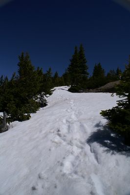
I took the old aerial tram in Teton Village up to the top of Rendezvous Mountain to try and hike down Garnet (aka Granite, a misnomer for the basalt formation) Canyon. The snows were pretty thick down to about 8,000 feet. I was starting my hike at 10,400 feet. The first 50 feet or so were snow-free. I was able to follow the trail via familiarity and map use for about 2 miles, but it was increasingly difficult, because the trail moves along the North side of the mountain, which melts slower than better exposures. I was post-holing up to my butt. I also had my new Leki trekking poles (read "canes"), and Yak Trax attached to my hiking shoes. The only things I really needed were snowshoes and a gps unit, because I was having difficulty determining the trail location, because all ground surfaces were so beautifully white. There were also a number of snow corniches, or overhangs, that I didn't want to try. So, after reaching an open area in which I wasn't sure of the next direction, I turned back. I took this shot when I decided to turn back, turning to look at my foot steps. Another reason I didn't continue: no other footsteps to confirm trail location. This section was nice and firm, but I really need the shoe grips and the poles to get back up the 2 miles or so that I'd begun hiking down. That was the most difficult hiking I've ever done. After I got back up to the top, I encountered the afternoon paragliders.


No comments:
Post a Comment