Monday, October 10, 2005

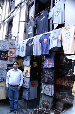
...and an exterior shot of the shop. Well done, old boy! Posted by Picasa
An interior shot of Sushil's shop... Posted by Picasa
Well, I found Sushil in the back of his shop, just a few paces down from where we met all those years ago.  Posted by Picasa
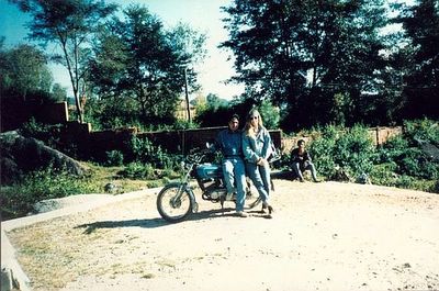
This is a photo of my friend Sushil Shresta and I in 1993. During that time in Nepal, Sushil and I were fast friends, along with Randy the Canadian, and we toured about the Kathmandu Valley by morotcycle. My hair is a little darker now, and Sushil and Randy both have families now, but I thought I'd stroll through Thamel Tole in Kathmandu to see if Sushil's tourist items shop was still there.  Posted by Picasa

Friday, October 07, 2005

Some photos from Nepal......maybe.


It is raining today in Koh Samui, so I am taking a break from mopeding around soaking wet to see if I can upload a few shots from an internet cafe, without the previously required software download from e-blogger. It seems the website has activated the "attach photo" function without you having to locally download Google's Picassa program, but It is taking a painfully slowly drawn out length of time. I guess that is what these last few days of the trip are for....nothing in particular.

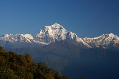
This photo is of Annapurna I, part of the Himalaya chain consisting of the Annapurna range in west central Nepal. Most trekking activity for this region eminates from Pokhara, though special envoys can be helicoptered in at any point within the Annapurna Conservation. At any rate, this ended up being the high point of my trek, both mentally and physically. We started hiking a few hundred meters above sea level and wound up at about 3400 meters, or 10,200 feet. Not exceptionally high altitude....I have enjoyed hiking at higher levels, but the difficulty in getting here was two fold.

One is that the Nepalis, echoed in the Loney Planet guide, tend to hearitly believe that the shortest distance between two points is a straight line. This works fine in geometry, but is a horrible practice put to use in the mountains. The pathways between villages act as highways for the life between those villages. They may only be a few feet or a few inches wide, but across these paths travel all of the goods and trekkers in the region, from livestock to mercantile supplies. These are not hiking trails in the sense that a Westerner might expect, they are effectively sidewalks...flagstoned all the way, and in the case of straight lines, these walkways are stairs climbing miles up the hills. "Hiking" them is more difficult than a typical trail, because you aren't really just walking, you're bringing your legs and knees just a little higher. Prior to reaching this photo vantage point, I would guess that I climbed up at least 15,000 stairs. Yes, the scenery and imersion into medieval villages is significant and rewarding, but it's a punishment to the knees that I did not quite expect.

The second difficulty was with the Maoist Rebels. They had previously announced a 3 month cease fire, probably growing more painfully aware that the cuts in tourism significantly cut into their revenue stream. Even though no tourist has been harmed (an often repeated statistic), approximately 10,000 people have died in crossfires between the rebels and the national security (army), including tolls on both sides. More alarming to me is the continuous and increasing frequency of dissaperances that seem to echo Pinochet. Not the best way for the rebels to get their message out. I can understand the frustration of rural people with their governement. It is a totalitarian, dictatorial monarchy. The current king is in power under suspicious circumstances after the 2001 masaccre of the royal family....the crown prince machine gunned down his family before reportedly killing himself, and the deceased king's brother, living a life of luxury in Thailand, was brought into power. The royal family was immediately cremated which continues to be a source of suspicion. At any rate, the new king has had increasing pressure from the maoists, rural persons banded together under some very seemingly contrary ideals. Mainly, they would like to see a democratically elected government, have clean water and utilities in rural areas, and schools where none exist....very human aspirations. The city of Kathmandu itself struggles with clean running water, as most city inhabitants need to draw water from a well pump, and reflect the highest rates of water borne diseases for non-flooded areas.

So, the Maoist rebels have been hanging out at Ghorepani along the Annapurna trekking circuit because of its strategic location. It is at the crossroads of three trekking options, and in the middle of a mountainous region accessible only by foot (or donkey or pony or helicopter, but essentially, when you run into them at this spot, there is no way to avoid them). I was staying at a lodge where there was a group of French people, and for some reason I was singled out to be asked for a "donation" (read extortion) in the amount of about $15 USD. My guide, who has become a dear friend and whom I hiked with specifically for this eventuality, said that I was French and didn't know what was going on. This was because I was asking what I got for my "donation", maybe a smile or a photograph.....At any rate, apparently Amerians and Britons are charged a higher "donation" rate, so I suppose I got discounted to the French contributory level....(no, not nothing, unfortunately......). The French at the guest house were hit up the next day for a lot more because they had guides and porters numbering about 30 people. Anyhow, the porters that night were eavesdropping on the Maoists and some bad **** was going to be going down the next day or so. My guide suggested after climbing up to see this sunset that we start back the way we came. That was fine with me, because while in Ghorepani, I stupidly accidentally erased all of the digital photos taken thus far, so this gave me a opportunity for some photographic backtracking. Unfortunately, it also gave me the opportunity for rubber legs and jello knees after descending those same 15000 plus damn stairs.

The next day it was reported that the rebels had abducted 335 locals to take them to the equivalent of jungle re-education camps. While the overall goal of democracy and common services throughout the contry is noble, the actions and history that the Maoists have decided to take certainly detract from that momentum.

So, anyway, here is the best sunrise photo of Annapurna I the morning we turned back from the trek.

It has now stopped raining and since I paid for the moped rental for all day, and am a way from the hotel area where I am later to coincidentally meet a vacationing co-worker and his wife for dinner, requiring a shower and better dress on my part, I have to be going.

Tuesday, October 04, 2005

Nepal Highlights So Far....watch this space for photos!

1. Trekking in the Annapurna region of W. Nepal

2. Accidentally erasing all the photos from my newfangled digital camera, but have had to take the same route back from the trek, so was able to recapture a number of them.

3. The trek was meant to be a loop but was turned back due to being stopped and "bribed" by maoist rebels. Have a whiz-bang receipt of my "donation", which I have read is becoming the souvenir de riguer for trekkers in Nepal.

4. Ran into a friend here from 12 years ago, a Nepali, and have made some more local friends (the Nepalis are the friendliest people on earth) so have had to actually turn down dinner invitations at various friends' homes because I'm fully booked. How cool is that!

5. Took an Everest sunrise flight this am....let's face it, I am never going to see it like that in my life by foot. Amazing, but overpriced.

Next Stop: Koh Samui and Kho Phangon, Thailand....stay tuned for photos.

Sunday, September 18, 2005

C A M B O D I A !! Posted by Picasa
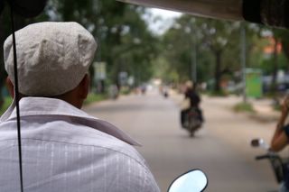
Photo from the back of a moto taxi in downdown Siem Reap. Interestingly, Siem Reap means Defeat of the Thais (Siamese), interesting considering the proximitey of Siem Reap to Thailand.  Posted by Picasa
This is a photo of James' hat. One of the most fun forms of transport in Siem Reap is by tuk-tuk, or basically a bench-wagon structure fastened to the back of a motorcycle. I didn't adjust the focus here to get the street, but did get a shot of James here. When you hire a ride, the driver will drop you off at the temple gates, and pull over into a food and souvenir stall area, and wait for you......however long it takes. I tried to tell him that he could go and I could find a ride when I was ready, but apparently this is not how it goes at Ankor. Your driver is yours for the day, however long you want to make it. Going rate is about $12 US for a day. Interestingly, the currency of choice is the US dollar everywhere in Siem Reap. It would be an interesting research topic to investigate the impact on the US dollar and US fiscal policy considering the various countries that use it as their defacto national currency as well.  Posted by Picasa
Ankor Wat, in all its afternoon lit glory. Posted by Picasa
Approach to Ankor Wat. Posted by Picasa
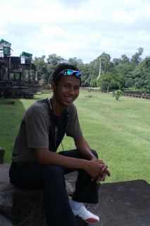
This is my friend Aeang, a high school teacher from Hanoi, which he considers the best city in Vietnam. He was traveling alone during a school holiday for a week, and I kept running into him asking different nationalities of tourists different questions. Usually when you see someone who looks local asking questions of tourists in lesser developed countries, the questions go something like, "what country are you from, what guesthouse are you staying in, do you want to buy ______, where are you going, do you have transport, do you have any coins from your country...etc. So, I was surprised to hear Aeang asking Japenese tourists what their standardized testing was like for high school aged children and what percentage of high scorers opt not to go to college. Or asking the French couple how to say "Entemologist" in French. He asked me to take his photo, and I noticed he was decked out in all the modern tourist garb. Digital camera, cell phone, mp3 player, sporty duds...unfortunately, there is such a huge economic gap between Cambodia and the rest of the world that these features really stand out on someone who seems remotely local. The next time I ran into him was at one of the relief panels and he was describing the depths of the Khmer empire when Ankor was built. It extended into China, southern Vietnam, Laos, and Thailand. He walked and talked with me for hours. While some of the information I took with a grain of salt, such as the Khmers being 7 foot tall, explaining the large holes in the huge stones that formed the temple (because the giants could pick them up with these finger grips), most was pretty informative and aligned with what I'd read. Even more interestingly, over freshly hacked coconuts for a drink, I asked him about Cambodia in the 1970's during the Khmer Rouge. He spoke in hushed tones...I know it is taboo to mention the subject to Cambodians, but thought he might take a teacherly approach to a quiet conversation after the time we'd spent talking history. Very sad...but I made a new friend and he provided excellent company for exploring Ankor Wat.  Posted by Picasa
This is the one shot I got at Bayon, in Ankor Thom, north of and larger than Ankor Wat, before my batteries died. Posted by Picasa
A buddha sculpture in Ankor Wat. Posted by Picasa
Another dancing aspara...but this one has been charcoal-rubbed (more on that below). Posted by Picasa